Technology
Europoltech 2017: “Police’s Silver Star” Award for Radmor
Gdansk-based Radmor company, belonging to the WB Group, has been awarded with the “Police’s Silver Star” distinction, for its SLW in-building localizing system.
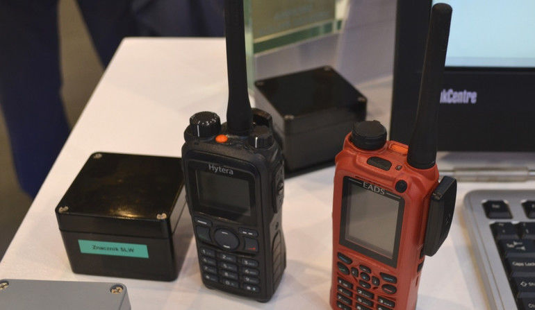
System Lokalizacji Wewnątrzbudynkowej (SLW – In-Building Localizing System) makes it possible to monitor the position of the persons utilizing the digital communication systems (such as TETRA or DMR), at locations where GPS signal remains out of reach. The aforesaid locations include, above all, buildings that are to great extent covered with steel structures, featuring a great quantity of pipelines and wiring, such as power stations. Within the infrastructure of the aforesaid type, the GPS signal strength is most often diminished, or even jammed.
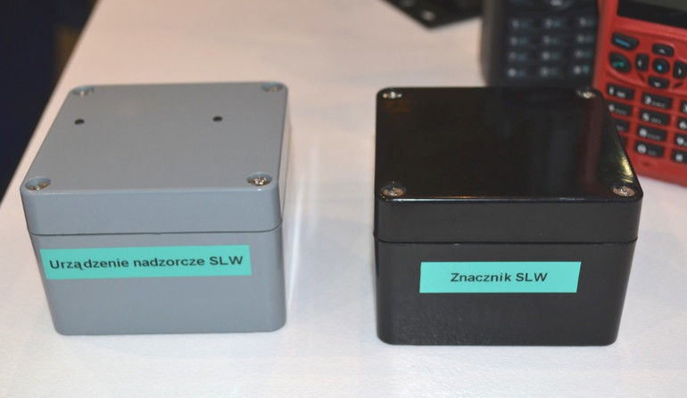
SLW is based on radio markers displaced all around the buildings, at thoroughly planned locations (in case of a similar system installed within one of the power stations located in the southern part of Poland, 700 marker locations have been arranged). Each of the markers, in a continuous manner, with a 1 second interval, emits a GSM 868 MHz signal, containing the following information: ID (Unique ID), battery voltage level and, should a need emerge, the recorded temperature.

In cases when a person carrying the radio with a reader appears in the range of operation of the marker (featuring an embedded reader, or a reader in a form of an extra PCB embedded within the radio), then the said reader would receive a signal from the marker, decoding it and sending the relevant radio signal (containing the ID, battery level and temperature) to the central unit.
Once one is aware of the displacement of the markers, then localizing the radio within the building with a high degree of precision is possible, by using the ID information contained within the signal. By tracking the ID changes pertaining to the signals sent by the radio, one may also define the route along which the user conducts his movement. “The location where the user is, is visualized with the use of a special application, integrating the terrain maps and building plans on a single screen”.
The accuracy of the SLW solution depends on the number of markers arranged within the building. The positioning is not achieved through any sort of triangulation, solely a signal with defined ID information is used. When one enters the range of operation of the marker, the information may be obtained suggesting that a given person remains within the range, which is then visualized on the plan.
A greater accuracy of positioning, e.g. indoors, is obtained through dense arrangement of the markers and power-output adjustment, so that the ranges do not interfere. In general, the spacing between the markers shall be kept within the range between 2 to 10 meters. Thus, the markers shall be installed at the very beginning of the process of the system set up within the given infrastructure, with assumptions made, with a reference to the signal level.

Later, when the system’s operation is initiated, the optimization process begins. Should solely a PC be used for that purpose, with slow reprogramming of the markers, the process could be time-consuming, as even several hundred markers may exist within a single system. Thus Radmor has also decided to develop a monitoring device which would establish a radio connection with the markers, also being in possession of an ability to properly change the marker parameters, such as signals, power output, ID, intervals. All of the above is done remotely - it is enough for the user to appear within the range of the markers.
Two methods exist, allowing the user to implement proper settings within the markers. The process may be conducted individually for each and every of the markers which are, in such case, individually connected to a proper application with the use of the monitoring device. However, automatic mode is also possible to be applied, in such case the software input is used within the device with parameters assignable even to several hundred markers. Then the user needs to walk around the whole area, carrying the programming system. The monitoring system uses an operating principle, in this case, similar to the one applicable in case of a “fillgun”. Once the operator reaches the individual markers, the relevant devices change their settings automatically. The whole process in question is also being recorded within the memory of the monitoring system.
In this way, one may learn about the process of reprogramming the markers and the method in which this is done. Once the operator completes his “walkaround”, the data is then transferred to the computer, and a special application indicates whether the procedure has been accomplished correctly. The whole process is very simple, as the monitoring device features only two diodes, signalling the status of the operation which is being conducted.


